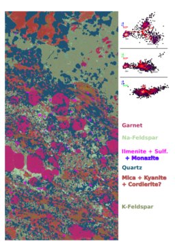
Image segmentation gallery
Maps collected to date
- 251222 -- Three thin sections mapped with two resolution settings (two recipes): 16 microns for WDS and 40 microns for EDS
- 251010 -- Mystery mineral. Looks like I was partially through doing the segmentation calculations for this one.
- 240313 -- Alloy. Might be interesting to try segmentation even though phases may be similar and I recall gradient effects. Other project folders with similar dates.
- 240319 -- Somma. Comparing various methods (?) vs HSCA.
- 241007 -- BRC map
- ?????? -- maps for A.C.
- 250318 -- (under J.S.) maps for M.C. and J.S (BAK)
- 241126 -- Lawsonite thin section
- 230501 -- J.P. Norway
- 230504 -- Fork Mountain
- ?????? -- D.M. UKY
- 230717 -- Bris-1
- ?????? -- Brenham
- 230424 -- under J.A. Fe alloy
- ?????? -- Carbonate concretion
Maps that I have actualy processed
Note: at the time of writing, I have adopted the following workflow to process my maps:
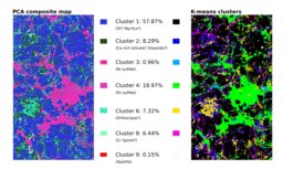
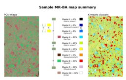
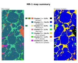
- Use my R segmentation script to calculate PCA images, K-means clusters, and retrieve mean pixel brightness for each element map.
- Use Inkscape to create a summary document combining PCA map and K-means clusters with a color key.
- Use ImageJ to retrieve the area percentage of each cluster and come up with a starting guess for the phases represented by each cluster. Then, add this information to the image summary document.
- Start a thread using Google AI Studio, and ask the following questions (exact prompts given in AI summary documents for each map):
- Based on the map summary, tell me everything about the rock.
- Come up with 10 guesses about where the rock was collected.
- Based on the pixel brightness, verify the phase identities.
- Calculate the composition of each phase
- Any other questions specific to the rock (e.g. a P-T-t path in the case of a metamorphic rock
- Describe the textures present in the uploaded images
- Choose the most likely sampling location based on all of the available information.
- Copy and format the AI chat as a .pdf document.
- Upload everything to this website.
So far, I have not checked any of the AI output for accuracy, but this should be straightforward to do by applying this workflow to a sample for which I know the location and/or composition of the major phases.
4/3/2026 Update:
After sharing the results from a sample of blueschist with some colleagues familiar with the rock, it is clear that the AI result is mostly bogus. Basically, it seems like a tremendous amount of weight is given to the presence of glaucophane in the rock, and most of the output reflects generic information about blueschist in general rather than any observations or calculations pertaining to the specific sample in question. The information supplied by the model isn't totally wrong, but it has no value because its provenance is unclear.